Few hikes in Kenya offer the perfect blend of adventure, breathtaking scenery, and accessibility quite like Mount Longonot National Park. Rising dramatically from the floor of the Great Rift Valley, this extinct stratovolcano attracts thousands of hikers every year with its steep trails, sweeping views, and one of the country’s most impressive volcanic craters.
Whether you’re an experienced trekker looking for a challenging day hike or a beginner hoping to conquer your first mountain, this Mount Longonot hiking guide will help you prepare for an unforgettable adventure.
From the moment you begin climbing its dusty slopes to the rewarding walk around the crater rim, every step reveals spectacular views of the Great Rift Valley, Lake Naivasha, and the surrounding volcanic landscape.
In this guide, you’ll discover everything you need to know before hiking Mount Longonot, including the hiking trail, difficulty level, entrance fees, the best time to visit, what to pack, and practical tips to help you enjoy the hike safely.
Why Hike Mount Longonot?
Mount Longonot is one of Kenya’s most popular hiking destinations, and for good reason. Unlike multi-day mountain expeditions that require technical equipment and extensive planning, Mount Longonot can be completed in a single day while still delivering an exciting and rewarding experience.
Its relatively short distance from Nairobi also makes it one of the best weekend getaways for nature lovers and adventure seekers.
What truly sets this hike apart is the opportunity to climb an extinct volcano and walk around its enormous crater. Few hiking destinations in East Africa allow visitors to experience a volcanic landscape this closely while enjoying panoramic views in every direction.
On a clear day, you’ll see the shimmering waters of Lake Naivasha, the dramatic cliffs of the Great Rift Valley, rolling hills, acacia woodlands, and distant volcanic peaks that define Kenya’s central highlands.
Every section of the trail offers something different, making the journey just as memorable as reaching the summit.
Where Is Mount Longonot?
Mount Longonot is located within Mount Longonot National Park in Nakuru County, approximately 90 kilometers northwest of Nairobi.
The mountain lies just off the Nairobi–Naivasha highway, making it one of the easiest national parks to reach from the capital. Depending on traffic, the drive usually takes between one and a half and two hours.
Its convenient location means many visitors combine the hike with other attractions in the Naivasha area, creating a full day of adventure in the Great Rift Valley.
If you’re planning a road trip through the region, Mount Longonot also fits perfectly into a wider itinerary that includes Hell’s Gate National Park, Lake Naivasha, Crescent Island, or Lake Elementaita.
What Makes Mount Longonot Special?
Mount Longonot isn’t simply another hill to climb, it’s one of Kenya’s youngest volcanoes, formed thousands of years ago through powerful volcanic eruptions that shaped the surrounding Rift Valley.
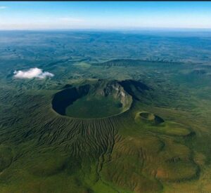
Although the volcano is considered dormant today, its massive crater remains one of the country’s most striking geological features.
The name Longonot comes from the Maasai word Oloonong’ot, meaning “mountains of many spurs.” The name perfectly describes the rugged ridges and steep slopes that hikers encounter on their ascent.
The mountain rises to an elevation of approximately 2,776 meters (9,108 feet) above sea level, while its crater measures nearly two kilometers across. Walking around the crater rim offers uninterrupted views into the densely vegetated crater below, where thick forest has reclaimed much of the volcanic landscape.
Because of its geological significance, diverse wildlife, and spectacular scenery, Mount Longonot was gazetted as a national park and is managed by the Kenya Wildlife Service (KWS).
You can also explore other geological landscapes in Kenya in our guide on Kenya’s geological wonders.
What to Expect During the Mount Longonot Hike
One of the biggest mistakes first-time visitors make is assuming Mount Longonot is an easy walk because it can be completed in a day.
In reality, the hike is physically demanding, especially during the first half. The trail climbs steadily uphill over loose volcanic soil, exposed rocky sections, and a series of steep inclines that can quickly test your endurance.
However, the challenge is part of what makes reaching the crater rim so satisfying.
As you gain elevation, the landscape changes dramatically. The park entrance soon disappears behind you, replaced by expansive views stretching across the Great Rift Valley.
The higher you climb, the cooler the breeze becomes and the more dramatic the scenery unfolds.
By the time you reach the crater rim, you’ll understand why Mount Longonot is considered one of Kenya’s most rewarding day hikes.
The Mount Longonot Hiking Trail: Step-by-Step
The complete Mount Longonot hike consists of three main sections. Each offers a unique experience and gradually builds towards the spectacular crater rim circuit.
Section One: From the Park Gate to the Summit
Your adventure begins at the Kenya Wildlife Service gate, where a clearly marked trail leads towards the mountain.
The first section is almost entirely uphill.
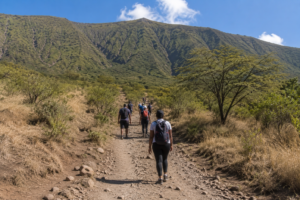
Although the distance may appear manageable on paper, don’t underestimate this climb. The trail gains elevation quickly, with several steep stretches that require steady pacing.
Fortunately, there are plenty of places where you can stop to catch your breath while taking in increasingly impressive views behind you.
As you continue climbing, you’ll notice the vegetation gradually becoming less dense, giving way to open volcanic terrain.
Keep an eye out for zebras grazing on the lower slopes and birds soaring overhead.
Depending on your fitness level, reaching the crater rim usually takes between one and two hours.
The final climb is the steepest, but also the most rewarding.
Once you step onto the rim, you’re greeted by one of the most spectacular volcanic landscapes in Kenya.
Section Two: Walking Around the Crater Rim
Many hikers think reaching the crater rim marks the end of the adventure. In reality, it’s only halfway.
The full crater rim circuit is what transforms a good hike into an unforgettable one.
Stretching for roughly 7 kilometers, the loop circles the entire crater, offering constantly changing views of the lush forest growing inside the volcano and the surrounding Great Rift Valley.
Unlike the initial ascent, this section alternates between gentle climbs, descents, narrow ridges, and flatter stretches.
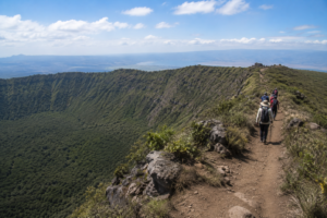
Some sections are shaded by small trees, while others are fully exposed to the sun.
As you walk, you’ll notice how the scenery changes with every turn.
On one side lies the dramatic crater interior, blanketed by thick vegetation. On the other, the vast Rift Valley stretches toward Lake Naivasha, with rolling hills and distant escarpments fading into the horizon.
Because fewer visitors complete the full loop, this part of the hike often feels quieter and more peaceful.
It is also the best place to stop, take photographs, and appreciate the remarkable scale of the volcano.